Portal:África
 | Estado de mantenimiento del portal: (abril de 2019)
|

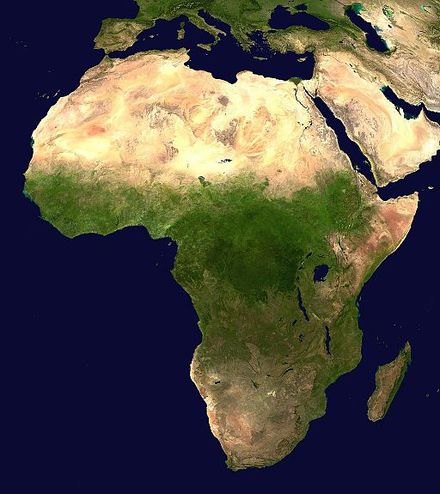

África es el segundo continente más grande y más poblado del mundodespués de Asia . Con unos 30,3 millones de km2 ( 11,7 millones de millas cuadradas) incluidas las islas adyacentes, cubre el 20% de la superficie terrestre de la Tierra y el 6% de su superficie total. Con casi 1.400 millones de personas en 2021, representa aproximadamente el 18% de la población humana mundial. La población de África es la más joven entre todos los continentes; la edad media en 2012 era de 19,7 años, cuando la edad media mundial era de 30,4. Según las proyecciones de 2024, la población de África alcanzará los 3.800 millones de personas en 2099. A pesar de una amplia gama de recursos naturales , África es el continente menos rico per cápita y el segundo menos rico por riqueza total, por delante de Oceanía . Los académicos han atribuido esto a diferentes factores, entre ellos la geografía , el clima , la corrupción , el colonialismo , la Guerra Fría y el neocolonialismo . A pesar de esta baja concentración de riqueza, la reciente expansión económica y una población grande y joven hacen de África un mercado económico importante en el contexto global más amplio. África tiene una gran cantidad de recursos naturales y recursos alimentarios, incluidos diamantes , azúcar , sal , oro , hierro , cobalto , uranio , cobre , bauxita , plata , petróleo , gas natural , granos de cacao y.
África se extiende a lo largo del ecuador y el meridiano principal . Es el único continente que se extiende desde las zonas templadas del norte hasta las templadas del sur. La mayor parte del continente y sus países se encuentran en el hemisferio norte , con una porción sustancial y varios países en el hemisferio sur . La mayor parte del continente se encuentra en los trópicos, a excepción de una gran parte del Sahara Occidental , Argelia , Libia y Egipto , el extremo norte de Mauritania y la totalidad de los territorios de Marruecos , Ceuta , Melilla y Túnez , que a su vez se encuentran por encima del trópico de Cáncer , en la zona templada del norte . En el otro extremo del continente, el sur de Namibia , el sur de Botsuana , gran parte de Sudáfrica , la totalidad de los territorios de Lesoto y Eswatini y los extremos meridionales de Mozambique y Madagascar se encuentran por debajo del trópico de Capricornio , en la zona templada del sur .
África es un continente con una gran biodiversidad , el que alberga el mayor número de especies de megafauna , ya que fue el menos afectado por la extinción de la megafauna del Pleistoceno . Sin embargo, África también se ve muy afectada por una amplia gama de problemas ambientales , como la desertificación, la deforestación, la escasez de agua y la contaminación . Se espera que estas arraigadas preocupaciones ambientales empeoren a medida que el cambio climático impacte en África . El Grupo Intergubernamental de Expertos sobre el Cambio Climático de las Naciones Unidas ha identificado a África como el continente más vulnerable al cambio climático .
La historia de África es larga, compleja y variada, y a menudo ha sido subestimada por la comunidad histórica global . En las sociedades africanas se venera la palabra oral , lo que ha llevado a los antropólogos a denominarlas civilizaciones orales en lugar de civilizaciones alfabetizadas . El proceso histórico es en gran medida comunitario , con relatos de testigos oculares, rumores , reminiscencias y, ocasionalmente, visiones , sueños y alucinaciones, elaborados en tradiciones orales . El tiempo es a veces mítico y social, y la verdad generalmente se considera relativista . La falta de registros escritos completos ha significado que la historiografía africana fue concebida en gran medida por extranjeros ( europeos y árabes ) que aún tienen la tarea de construir los marcos institucionales, incorporar epistemologías africanas y representar una perspectiva africana. ( Artículo completo... )
Artículo seleccionado –
La Unión Africana ( UA ) es una unión continental de 55 estados miembros ubicados en el continente africano . La UA fue anunciada en la Declaración de Sirte en Sirte, Libia , el 9 de septiembre de 1999, en la que se pedía el establecimiento de la Unión Africana. El bloque se lanzó el 9 de julio de 2002 en Durban , Sudáfrica . La intención de la UA era reemplazar a la Organización de la Unidad Africana (OUA), establecida el 25 de mayo de 1963 en Adís Abeba por 32 gobiernos signatarios; la OUA se disolvió el 9 de julio de 2002. Las decisiones más importantes de la UA las toma la Asamblea de la Unión Africana , una reunión semestral de los jefes de estado y de gobierno de sus estados miembros.
La secretaría de la UA, la Comisión de la Unión Africana , tiene su sede en Adís Abeba . La ciudad más grande de la UA es Lagos (Nigeria), mientras que la mayor aglomeración urbana es El Cairo (Egipto) . La Unión Africana tiene más de 1.300 millones de habitantes y una superficie de unos 30 millones de km2 ( 12 millones de millas cuadradas) e incluye lugares de interés mundial como el Sahara y el Nilo . Los principales idiomas de trabajo son el árabe , el español , el francés , el inglés , el portugués y el suajili . Dentro de la Unión Africana hay organismos oficiales, como el Consejo de Paz y Seguridad y el Parlamento Panafricano . ( Artículo completo... )
Imágenes destacadas –
Sabías(generado automáticamente)-

- ... que el activista sudafricano de derechos civiles Thambi Naidoo fue arrestado junto con Mahatma Gandhi y enviado fuera de Transvaal por negarse a registrarse ?
- ... que Agri-Expo es la sociedad agrícola más antigua de África?
- ... ¿que la jugadora olímpica de rugby estadounidense Sarah Levy es bisnieta de un Springbok ?
- ... que el Instituto Phoenixonian fue la primera escuela secundaria afroamericana en California?
- ... que Freedom of Religion South Africa presentó una demanda infructuosa para mantener legal la nalgada a los niños ?
- ... que los miembros de The Links , una organización de élite de mujeres negras de clase alta , incluyen a Betty Shabazz , Marian Wright Edelman y Kamala Harris ?
Categorías
Biografía seleccionada –
Chimamanda Ngozi Adichie ( / ˌ tʃ ɪ m ə ˈ m ɑː n d ə ə ŋ ˈ ɡ oʊ z i ə ˈ d iː tʃ i . eɪ / ; nacida el 15 de septiembre de 1977) es una novelista,cuentistay activista nigeriana. Considerada una figura central dela literatura feminista poscolonial, es autora de las novelasPurple Hibiscus(2003),Half of a Yellow Sun(2006) yAmericanah(2013). Entre sus otras obras se incluyen los ensayosWe Should All Be Feminists(2014);Dear Ijeawele, or A Feminist Manifesto in Fifteen Suggestions(2017); una autobiografía,Notes on Grief(2021); y un libro infantil,Mama's Sleeping Scarf(2023).
Adichie nació y creció en Enugu , la capital del estado de Enugu . Después de su educación secundaria, se trasladó a la Universidad de Nigeria , donde fue editora de la revista de la escuela, The Compass . A los diecinueve años, dejó Nigeria para ir a los Estados Unidos, para realizar estudios superiores en la Universidad de Drexel , y más tarde estudiaría en tres universidades: Eastern Connecticut State University , Johns Hopkins University y Yale University . Adichie creció de forma bilingüe y escribe en inglés e igbo . Citando a Chinua Achebe y Buchi Emecheta como su inspiración, publicó por primera vez Decisions , una colección de poesía, en 1997, a la que siguió una obra de teatro, For Love of Biafra , en 1998. La historia de su padre durante la guerra le proporcionó material para su segunda novela Half of a Yellow Sun. ( Artículo completo... )
País seleccionado –
 |  | |
 | ||
Benín , oficialmente República de Benín , es un país de África Occidental , anteriormente conocido como Dahomey (hasta 1975). Limitaal oeste con Togo , al este con Nigeria y al norte con Burkina Faso y Níger ; su corta costa al sur conduce a la bahía de Benín . Su capital es Porto Novo , pero la sede del gobierno es Cotonú . Su política se desarrolla en el marco de una república democrática representativa presidencial , en la que el presidente de Benín es a la vez jefe de Estado y jefe de Gobierno , y de un sistema multipartidista .
El nombre "Benín" no tiene ninguna conexión propia con el Reino de Benín (o Ciudad de Benín ). El nombre Dahomey fue cambiado en 1975 a República Popular de Benín, llamado así por el cuerpo de agua en el que se encuentra el país, la Bahía de Benín . Este nombre fue elegido debido a su neutralidad, ya que las fronteras políticas actuales de Benín abarcan más de cincuenta grupos lingüísticos distintos y casi la misma cantidad de grupos étnicos individuales. El nombre Dahomey era el nombre del antiguo Reino Fon , y se determinó que era un nombre inapropiado. ( Leer más... )
Ciudad seleccionada –
Bangui ( pronunciación francesa: [bɑ̃ɡi] ; o Bangî en sango , anteriormente escrito Bangi en español) es la capital y la ciudad más grande de la República Centroafricana . Fue establecida como un puesto avanzado francés en 1889 y recibió su nombre por su ubicación en la orilla norte del río Ubangi ( en francés : Oubangui ); el propio Ubangi recibió su nombre de la palabra bobangi para los "rápidos" ubicados junto al asentamiento, que marcaban el final del agua navegable al norte de Brazzaville . La mayoría de la población de la República Centroafricana vive en las partes occidentales del país, en Bangui y sus alrededores.
La ciudad forma parte de la prefectura de Bangui desde diciembre de 2020. En 2020 [update]tenía una población estimada de 889.231 habitantes. ( Artículo completo... )
En las noticias
- 12 de febrero de 2024 –
- Dos barcos chocan en el río Congo cerca de Kinshasa , República Democrática del Congo ; el número de muertos aún no está claro. (AP)
- 11 de febrero de 2024 – Copa Africana de Naciones 2023
- En fútbol , Costa de Marfil, el país anfitrión, ganó su tercera Copa Africana de Naciones al derrotar a Nigeria por 2-1 en la final . Sébastien Haller marcó el gol de la victoria en el minuto 81. (The Guardian)
- 10 de febrero de 2024 – Guerra civil somalí
- Cuatro soldados emiratíes y un oficial militar bahreiní mueren y otras diez personas resultan heridas cuando un soldado abre fuego en una base militar en Mogadiscio , Somalia , antes de morir en el tiroteo que siguió . Al-Shabaab se atribuye la responsabilidad. (AP)
- 10 de febrero de 2024 –
- Un helicóptero Eurocopter EC130 se estrella cerca de Nipton , California , Estados Unidos , y mueren las seis personas que iban a bordo, entre ellas el banquero nigeriano Herbert Wigwe . (CBS News)
- 10 de febrero de 2024 – 2023-2024 Protestas en Senegal
- Violentas protestas en Senegal tras el anuncio del presidente Macky Sall de que las elecciones presidenciales se han pospuesto del 25 de febrero al 15 de diciembre. (Sky News)
- 9 de febrero de 2024 –
- Al menos 18 personas mueren durante una colisión entre un autobús y un camión en una carretera en Kinshasa , República Democrática del Congo . (AP)
Actualizado: 16:33, 14 de febrero de 2024
Imágenes generales -
Temas de África
¿Sabías más?
- ...que miembros del grupo de rap senegalés Daara J fueron contratados por los activistas de las elecciones senegalesas de 2000 para editar sus discursos?
- ...que la abreviatura del nombre del grupo de hip hop senegalés Positive Black Soul , PBS, es un juego de palabras con la del Parti Démocratique Sénégalais , PDS?
- ...que Mamadou Diabaté , un intérprete de kora maliense , fue nominado a un premio Grammy en 2005, pero perdió ante su primo Toumani Diabaté ?
- ...que, en noviembre de 2007, The Sowetan publicó un artículo que afirmaba erróneamente que el activista político sudafricano Dan Mokonyane había muerto?
Portales relacionados
Principales religiones en África
África del Norte
África occidental
África central
África Oriental
África del Sur
Wikimedia asociada
Los siguientes proyectos hermanos de la Fundación Wikimedia proporcionan más información sobre este tema:
Repositorio de medios libres Commons- Wikilibros
Libros de texto y manuales gratuitos - Wikidata
Base de conocimiento libre - Wikinoticias
Noticias de contenido libre
Colección de citas de Wikiquote
Biblioteca de contenido libre Wikisource
Directorio de especies de Wikispecies- Wikiversidad
Herramientas de aprendizaje gratuitas - Wikivoyage
Guía de viaje gratuita
Diccionario y tesauro Wikcionario


.jpg/440px-Africa_(satellite_image).jpg)


_adult_male.jpg/440px-Sable_antelope_(Hippotragus_niger)_adult_male.jpg)

.jpg/440px-Roan_antelope_(Hippotragus_equinus_koba).jpg)



.jpg/440px-SWA-15a-Swakopmunder_Buchhandlung-Two_Mark_(1916).jpg)
.jpg/440px-GEA-46a-Deutsch_Ostafrikanische_Bank-50_Rupien_(1915).jpg)


.jpg/440px-Lucy_(Frankfurt_am_Main).jpg)


.jpg/440px-Pre-Neolithic_and_Neolithic_migration_events_in_Africa_(excluding_Basal-West-Eurasian_geneflow_during_the_Paleolithic).jpg)




.jpg/440px-Brooklyn_Museum_L54.5_Fragment_of_a_Head_(3).jpg)


